

Macao may be a small place, but its role in the history of globalisation and international exchange is profound. This can be seen in historical records from China and abroad dating back to the Ming dynasty, as well as through the evolution of cartography. Maps, of course, do more than depict geographical features; they incorporate symbols, annotations and stylistic choices that reflect the perspectives of their creators, the societies that produced them and the historical contexts in which they were made.
The Macau University of Science and Technology (MUST) has been collecting maps of Macao since 2013. Today, it holds over 11,000 cartographic artefacts – mostly scanned or digital versions of the historic originals. The collection spans world maps, maps of China and the Pearl River Delta, and detailed renderings of Macao itself. Through assembling this impressive archive, MUST has not only enriched its own holdings but transformed the material into accessible data available for scholars worldwide to study. As its in-house researchers meticulously categorise and analyse the Global Mapping of Macao archive, they prepare fertile ground for new academic findings.
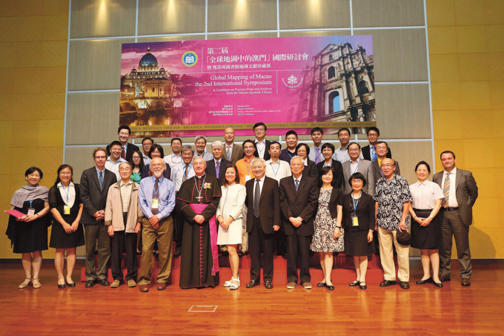
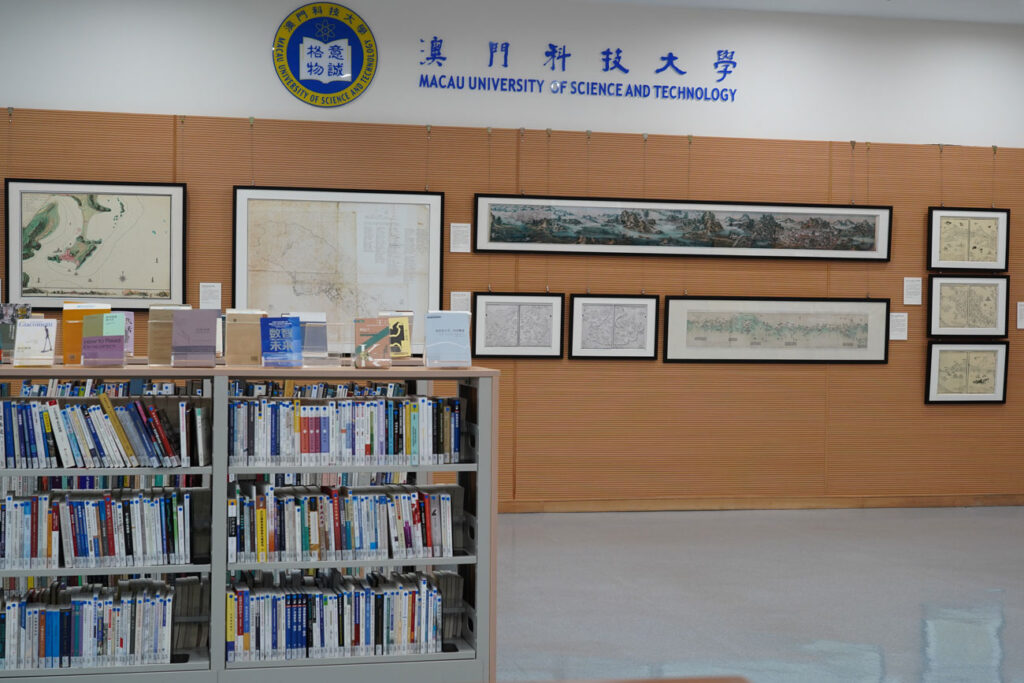
In December last year, MUST held its third exhibition showcasing a selection of its treasured maps, Global Mapping of Macao: Exhibition of Old Maps of the Guangdong-Hong Kong-Macao Greater Bay Area and Macao. The exhibition gained special significance when, on the eve of the 25th anniversary of Macao’s return to the motherland, President Xi Jinping visited the university’s Taipa campus to view the collection. While there, Xi met with students at MUST’s library. He expressed his delight in seeing them “full of vitality and confidence” and encouraged them to set ambitious goals for the future.
A Jesuit’s journey
MUST’s mapping initiative took root after a 2012 exhibition hosted by the Macao Museum, titled Journey to the Ends of the World: Michele Ruggieri and Jesuits in China. Commemorating the China-European Union Year of Intercultural Dialogue, the show displayed maps drawn by Jesuits that had been preserved in the National Archives of Rome for centuries. One of these was Ruggieri’s Atlas of China, its annotations written in Latin.
Born in the Kingdom of Naples (in today’s Italy, then part of the Spanish empire) in 1543, Ruggieri reached Macao via Goa in 1579. It was here that he began assiduously studying the Chinese language, efforts that eventually saw him described as the first European sinologist. He and fellow Jesuit Matteo Ricci went on to compile the first Portuguese-Chinese dictionary – considered an early milestone in cross-cultural communication. Both Ruggieri and Ricci spent time in Portugal and set sail to Asia from Lisbon together. In 1583, Ruggieri became the first European missionary allowed to reside in the mainland.
During Journey to the Ends of the World, a teacher at MUST emailed the director of the university’s library, Dai Longji, pointing out that these early maps seeemed like valuable materials for the study of Macao. Dai, formerly the director of the Peking University Library and an avid collector of atlases, agreed with the teacher’s assessment. He promptly began planning the creation of a special collection of ancient maps of Macao.
The goal was to “gather maps, geographic charts, and related data about Macao scattered across libraries, museums and archives worldwide, and to develop and utilise these materials to support research on Macao,” Dai noted in the afterword of a book of theses he later helped compile as part of the project.
Compiling a cartographic archive
Professor Zhang Shuguang, then-director of the Institute for Social and Cultural Research (ISCR) at MUST, was one of the project’s early leaders. He has described the long-term initiative as having three main objectives: first, to expand the global history of Macao as a research field; second, to create a special collection of world maps that feature Macao; and third, to develop a public database of Macao maps for educational purposes.
The Global Mapping of Macao project officially launched in September 2013, with initial funding of 1,000,000 patacas from the Macao Foundation. The research team included staff from the MUST Library and its Department of General Education, such as Professor Xu Ping, Assistant Librarian Yang Xunling, and the English lecturer Xiang Fang.
Their research unfolded in several key phases. The first involved reviewing literature on Macao and its historical connections with the rest of the world, especially around the city’s emergence as a hub for international trade between China and Portugal in the 16th and 17th centuries. This phase examined Macao’s role in East-West exchanges and its significance in the broader narrative of early globalisation (for a long time, Macao was China’s sole gateway to trading with the rest of the world).
The second phase focused on studying books about historical maps and cartography, with special attention given to maps of Macao and their authors. The goal here was to uncover the backgrounds of the mapmakers, the sources they used and how they processed their data.
The third phase involved hunting down cartographic catalogues in online archives around the world, notably from China, the United States, Portugal, the Vatican and other places in Europe. The MUST researchers then visited key locations in person, to scan or photocopy these maps. During their travels, they gathered additional information and compiled detailed bibliographies.
The maps were then categorised and digitised, making it possible for scholars everywhere to use MUST’s collection to study the history of Macao. It is worth mentioning that assistance from the Harvard-Yenching Library, the US Library of Congress, the Vatican Apostolic Library and the National Archive of Torre do Tombo in Portugal was instrumental in completing this part of the project.
Uncovering historical insights
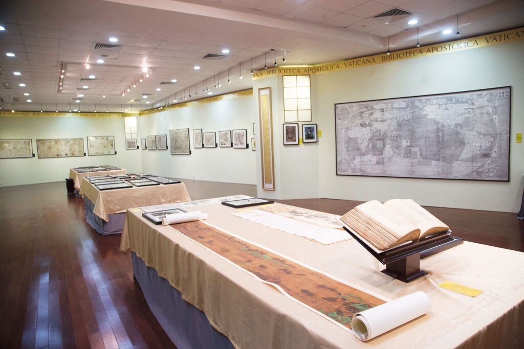
Over the past 12 years, Global Mapping of Macao has yielded a remarkable record of achievements. The project has produced four atlases, two volumes of academic theses and three exhibitions. A highlight was the Pearls in Paradise symposium and exhibition held in July 2015, which featured maps from the Vatican Apostolic Library’s archives. The event attracted scholars from Macao, Hong Kong and beyond, including Archbishop Jean-Louis Bruguès, then-librarian of the Vatican Apostolic Library, and the esteemed Chinese historian, Professor Qian Chengdan.
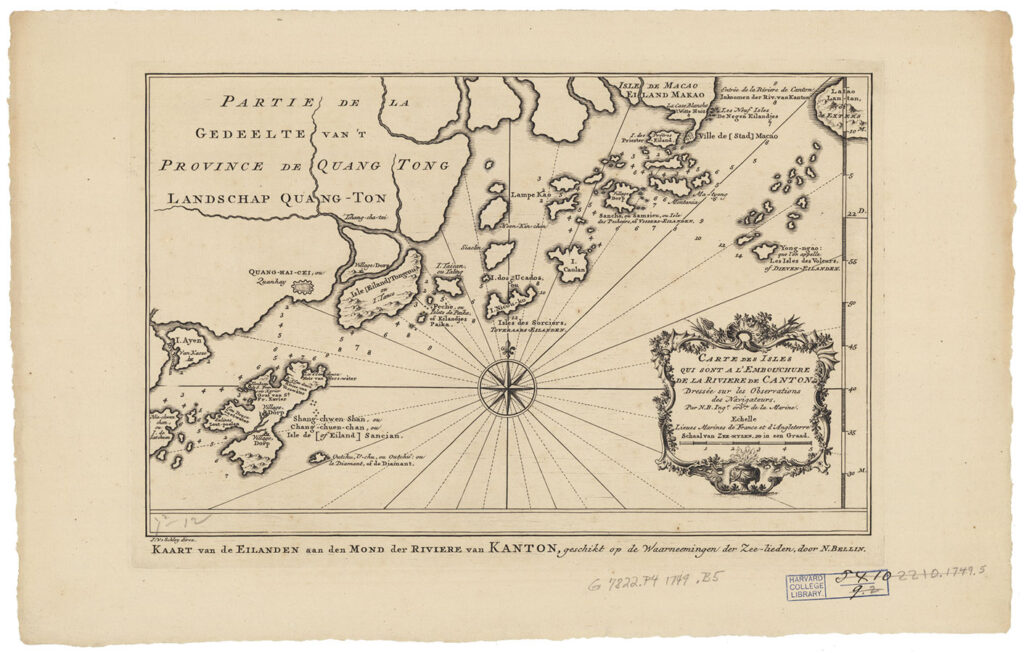
MUST published its first atlas relating to the project in 2014. Sailed to the East: Global Mapping of Macao included 50 ancient and valuable maps collected from libraries around the world. A second atlas followed in 2017, based on the Pearls in Paradise exhibition. It featured almost 100 maps, images and documents from the Vatican archives. Two further atlases were released in 2020 and 2024, respectively titled Global Mapping of Macao: Xiangshan and Global Mapping of Macao: Macao City & Harbor.
The papers published by the project’s team have helped advance academic dialogue relating to Macao’s position in global history. “History in Cartography: Macao in the 16th–19th Century Collision of Eastern and Western Civilizations”, for instance, put forward two key scholarly arguments. The first was that Macao’s unique geographic position allowed it to became a gateway for Westerners to understand Chinese culture, a trading port for the West to China and Southeast Asia, and a strategic location for military operations in nearby seas.
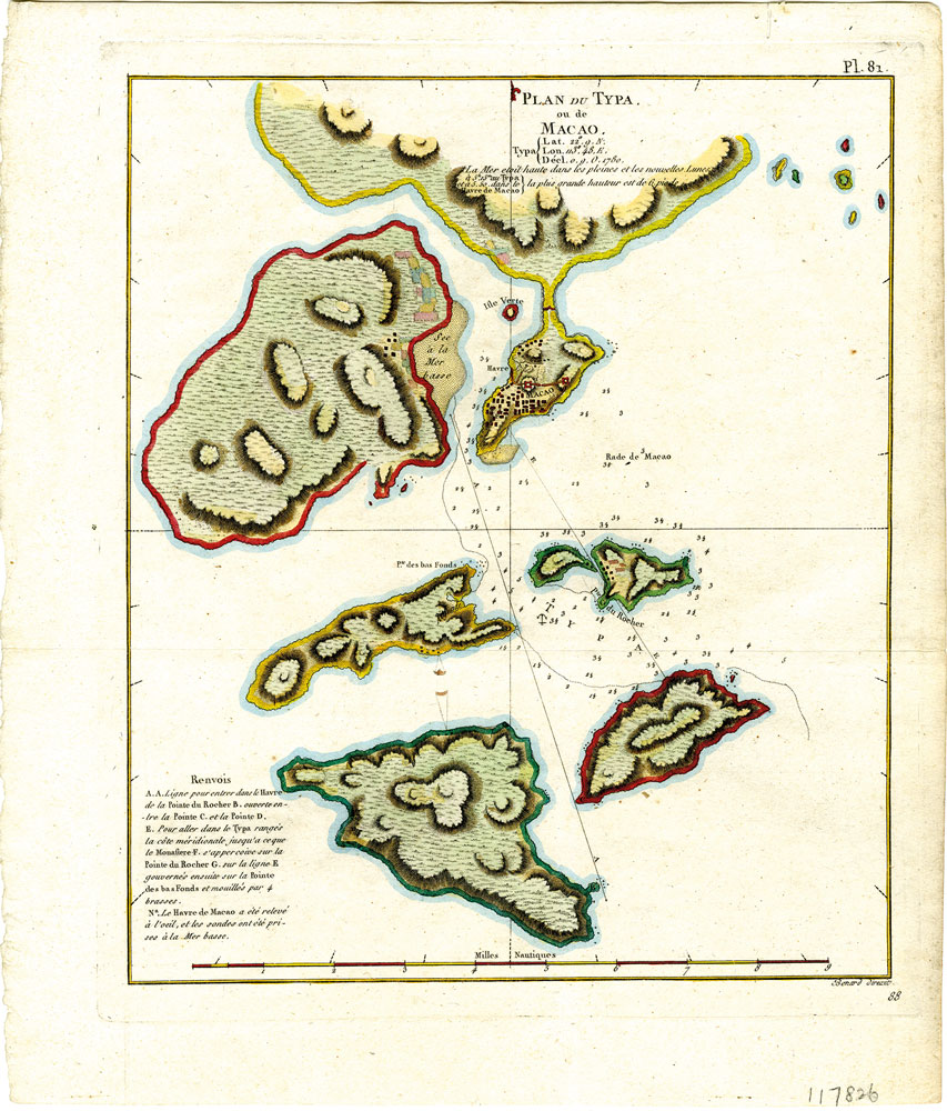
The second argument held that the development of Western maps of Macao was closely tied to maritime power struggles. Between the 16th and the 19th centuries, the shifting dynamics of countries such as Portugal, the Netherlands, Britain, France, Germany and the United States – as well as their naval competition in the Indian Ocean and South China Sea – were clearly documented in maps of Macao and its surrounding areas.
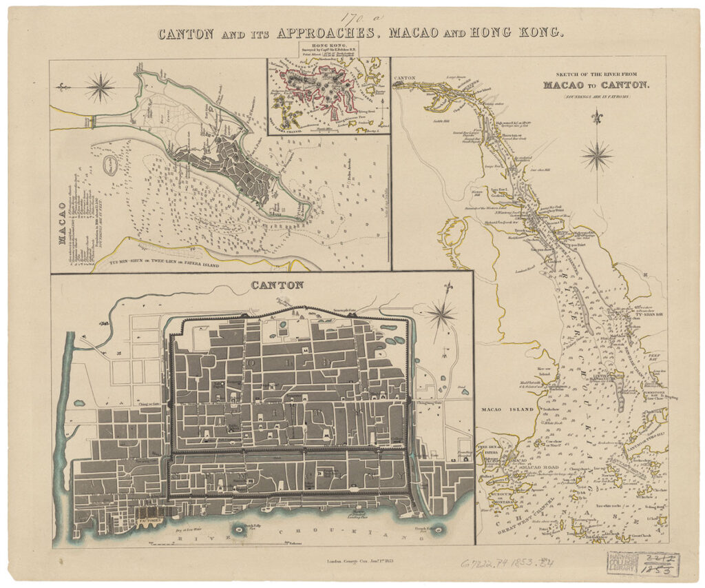
For instance, maps of the region created in 1853 by Sir Edward Belcher, a Canadian serving in Britain’s Royal Navy, show Britain’s maritime dominance by the mid-19th century. One of his maps features Macao in great detail, from the locations of its churches, hospitals, canons and local government, to its bodies of water. Through Belcher’s precision, scholars infer that the British had collected massive information about the Pearl River Delta and its constituents’ urban planning by that time.
Mapping the future
The numerous papers published based on studies of MUST’s antique maps are testament to the significant academic value of this collection. As Zhang has noted, scholars have shifted away from traditional paradigms treating all antique maps as reliable historical documents, and towards a more critical line of thinking that sees scholars and cartographers approach maps as products of their time – shaped by political, economic and ideological influences. Zhang also advocates for extending the study of ancient maps into the field of international history and globalisation.
As Macao continues to evolve, its historical role as a centre of trade and cultural exchange remains relevant. Under the ‘One Centre, One Platform, One Base’ strategic framework, the city is positioning itself as a World Centre for Tourism and Leisure; a trade hub between China and Portuguese-speaking countries; and a base for cultural exchanges with an emphasis on Chinese heritage. This framework can be described as a modern continuation of its centuries-old legacy.


